Christmas Eve Slide on S Diamond
Well, it's happened again. How many times have we seen a similar picture from Cameron Pass? I can remember at least a dozen over the past 15 years, meaning that this is a regular occurrence on South Diamond Peak. Understanding the historical slide paths is one thing, but if you've skied in the area over the past month you've probably run across some avalanche red flags that should have brought this memory to the forefront of your thoughts. Apparently this very large slide was remotely triggered from above - how many people have traveled below this area in the past week?
This picture was taken the day before from an area on South Diamond Pk that didn't slide in Christmas Eve's avalanche.
Tracks on Ptarmigan on Dec 23, 2016. Just beyond those tracks, past the small patch of trees went to the ground for the next 1,000 feet. The total area that we toured in that day did not slide, but did that give us enough of a margin of safety? That's really a personal decision - but one that should be a conscious decision, not just happenstance or something we talk about in the debrief.
What might slide next?
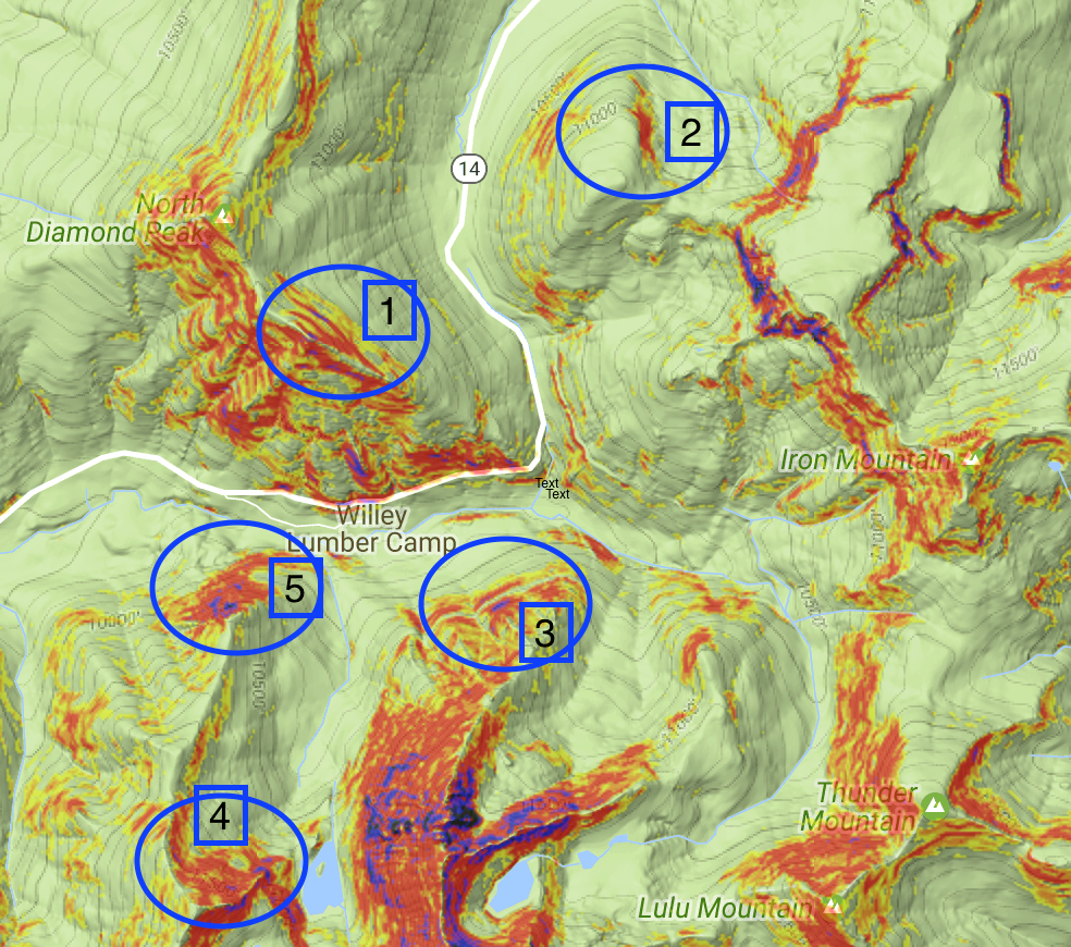
Where might you trigger similar avalanches in the near future? A quick view of the CalTopo overlay of Hillmap.com can give us some idea of this. Of course this is not comprehensive, but for the zones that I see regularly skied at Cameron Pass, here's the ones that have a similar slope and aspect as the the Christmas Eve slide. 1 - the S Diamond Pk slide on 12.24.2016. 2 - Hot Dog Bowl, slightly more easterly facing, but similar elevation and slope. I helped extract the last fatality out of this zone in 2007 so I keep careful track of this zone for sure. 3 - Longest Run zone, slightly lower elevation, but same slope and aspect. Just because this is skied a lot does not make it safe! Recall the Paradise Bowl fatality of 2012. 4 - Braddock Peak, although this is typically a spring destination, take caution in case this is on your list for mid-winter this season. 5 - Braddock Ridge - this zone is less often skied, but fairly easy access. It's lower than S Diamond, but proximity should give weight to similar snowpack conditions.
Use this information, as well as any other info you can gather from CAIC, friends, forums, travelers, etc, to inform your tour decisions for this season. Is this problem going to go away? If you choose different terrain are you decreasing the hazard or your risk? Do you know the difference? If not, join us for a Level 1 Avalanche course this season where we teach courses right at Cameron Pass. Be careful out there!! Choose terrain wisely and understand where your decisions are leading you.


